Home → Fishing & Boating → Fishing → Laws & Rules → Statewide General Fishing Laws
Statewide General Fishing Laws for Inland Waters
A valid fishing license is required. See License Requirements and Fees.
Terminal Gear
| North Zone | South Zone |
|---|---|
| Use or possession of live fish as bait is PROHIBITED. The use of all other legal forms of bait (including worms and dead baitfish/smelts), artificial lures, and artificial flies is PERMITTED. | Use of all legal forms of bait (including live baitfish/smelts), artificial lures, and artificial flies is PERMITTED. |
Seasons
| Lakes & Ponds | Rivers, Streams, Brooks | ||
|---|---|---|---|
| North Zone (See Map) |
From April 1 to September 30: Open to open water fishing. From October 1 to March 31: Closed to all fishing. |
North and South Zones | From April 1 to August 15: Open to open water fishing. From August 16 to September 30: Open to open water fishing using artificial lures or flies only. General law length and bag limits apply, except daily bag limit one landlocked salmon and one brook trout. From October 1 to March 31: Closed to all fishing. |
| South Zone (See Map) |
January 1 to December 31: Open to ice and open water fishing | ||
General Law Daily Bag, Possession and Length Limits
The daily bag, possession and minimum length limits in the table below apply to all inland waters open to fishing.
| Species | Daily Bag & Possession Limits | Length Limit | ||
|---|---|---|---|---|
| Lakes/Ponds | Rivers, Streams, Brooks | |||
| Brook Trout (incudes Splake & Arctic charr) |
5 fish Only 2 fish from South Zone lakes & ponds |
6 inches minimum | 6 inches minimum | |
| Brown Trout | 2 fish | 14 inches minimum | 6" min & 25" max | |
| Rainbow Trout | 2 fish | 12 inches minimum | 6 inches minimum | |
| Landlocked Salmon | 2 fish | 14 inches minimum | 14" min & 25" max | |
| Togue (Lake Trout) | 2 fish | 18 inches minimum | 18 inches minimum | |
| Species | Daily Bag & Possession Limits | Length Limit | ||
| Bass (Largemouth & Smallmouth) |
North Zone: Unlimited | None | ||
| South Zone: 2 fish | No minimum length. Only 1 may exceed 14 inches. | |||
| Whitefish | 3 fish | None | ||
| Smelts | 2 quarts | None | ||
| Sea-run Atlantic Salmon, Redfin Pickerel, Swamp Darter | Endangered or Threatened Species - No Fishing Permitted | |||
| Striped Bass, Shad, River Herring, American Eel, Sturgeon | See Recreational Angling for Migratory Fish | |||
| Inland species not listed above | Unlimited | None | ||
Why have two general fishing law zones?
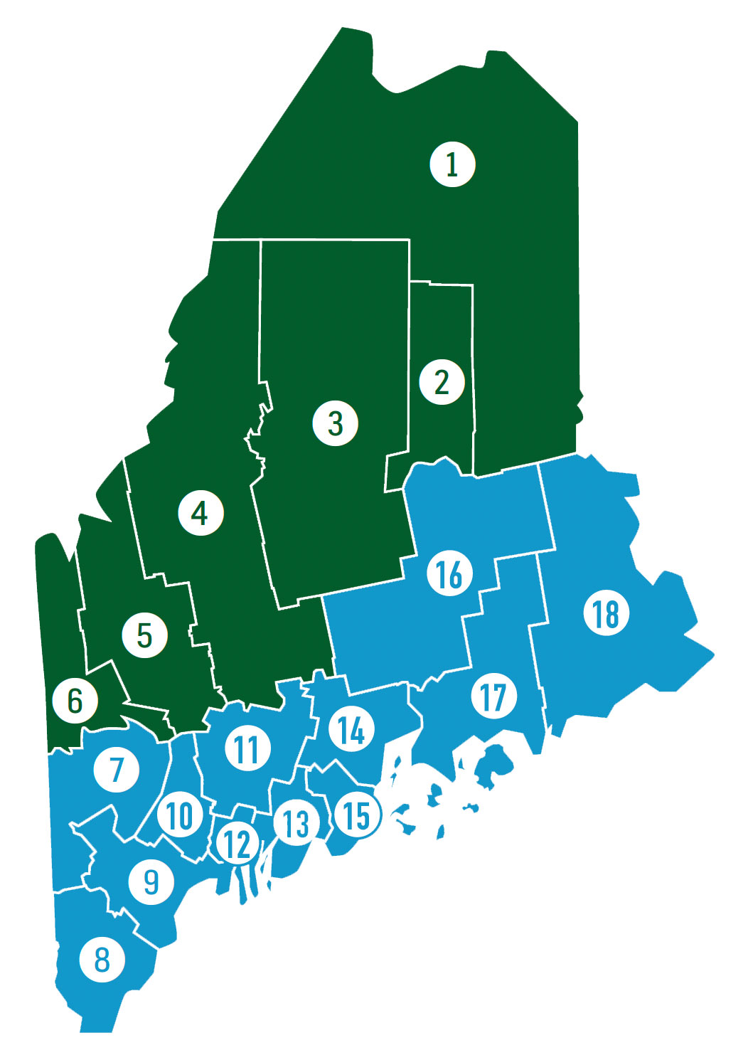
There are different General Law Season dates, Brook Trout Bag Limits, Terminal Gear Restrictions, and Bass Bag and Length Limits depending on zone, North or South.
The North Zone contains an abundance of wild and native coldwater fish populations, while the South Zone contains predominately stocked and/or warmwater fisheries. The difference in General Fishing Laws reflect the management needs for the two zones, and typically offer additional protection to wild and native resources in the North and more angling opportunity (i.e., fall or year round fishing) in the South.
North Zone Counties
- Aroostook
- Penobscot north of Route 11 & 157
- Piscataquis
- Somerset
- Franklin
- Oxford north of the Androscoggin River
South Zone Counties
- Oxford south of the Androscoggin River
- York
- Cumberland
- Androscoggin
- Kennebec
- Sagadahoc
- Lincoln
- Waldo
- Knox
- Penobscot south of Route 11 & 157
- Hancock
- Washington